Strange Maps: A Free-form Cartographic Journey

I love maps. I spend a lot of time looking at them, and always enjoy taking a spin around the globe we keep at the cafe, seeing where places are and checking out their relative size.
I was sent a book the other day that is a map-lover’s fantasy. Frank Jacobs has compiled a huge collection of what he calls Strange Maps: An Atlas of Cartographic curiosities.
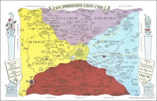
Among the maps I’ve enjoyed poring over is a map that goes way back to my childhood: L. Frank Baum’s map of the Marvelous Land of Oz. I used to work out on Martha’s Vineyard and I often thought of that place as much like Oz…there is the land of the Winkies, to the west, and Quadling Country to the South. In the very center is the Emerald City, and all around the square shaped mythical land are the great sands, impassable and deadly deserts.
This is a fun book to flip through, Jacobs has found so many old maps from so many points of view. Another page shows how Antarctica is divided up into 47 different slices, even little Togo gets a tiny slice and the USA gets the biggest (why is that?)
Jacobs has found other wonderful maps in this volume, like the ‘island of California,’ which goes back to a romantic novel written in 1510 that showed the Baja Peninsula attached to an island of California. Another page has an illustration of fifty different shapes drawn from memory by teenagers, who tried to replicate that unique shape of the United States. They somehow remind me of cows.

November 3, 2009 @ 4:20 pm
Hi Max, Good to meet you (briefly) at VEMEX yesterday. If you liked "Strange Maps," consider checking out Katharine Harmon's "You Are Here."